The 26 scenic byways of Colorado connect the dots between historic sites and acres of majestic scenery that span from red-rock canyons to the peaks of the Rocky Mountains to the sun-kissed prairie.
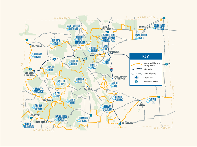
Click the byway name for details and suggested itineraries:
Guide your 4×4 over high-elevation 1880s roads past thick-with-wildflower meadows, abandoned mines, and ghost towns. And when riding OHVs through the Alpine Loop, make sure you follow Colorado’s off-roading motto of “Stay the Trail.”
Southwest region: Connecting the towns of Lake City, Ouray and Silverton.
Glimpse relics of frontier life along a route that climbs upward, with plants, animals and geology that change every 1,000 feet. Southeast Region: Between the city of Pueblo and the towns of Westcliffe and Colorado City.
Witness the centuries-old cliff dwellings and petroglyphs of the Ancestral Puebloans along the first Byway designated for archeological significance. Southwest Region: Connecting the Utah state line near Hovenweep National Monument and the Four Corners (where Colorado, New Mexico, Arizona and Utah meet at one point) through the city of Cortez, CO.
The state’s newest Byway follows the creation and development of the Denver & Rio Grande Railroad, the state’s first, and ultimately the nation’s largest, narrow-gauge railroad system, as well linking two of Colorado’s most important and existing historic narrow gauge railroads: the Durango & Silverton Narrow Gauge Railroad and the Cumbres & Toltec Scenic Railroad — both remaining parts of the San Juan Extension built in the early 1880s. The route travels the following roadways, south and east from Durango: U.S. 160 south and east to State Highway 172; State Highway 172 to Ignacio; State Highway 151 to north of Arboles; Archuleta County roads 500 and 551 east and south into New Mexico; Rio Arriba County road in New Mexico east to Dulce; and U.S. 64 east to Chama, NM.