Mt. Baker Scenic Byway
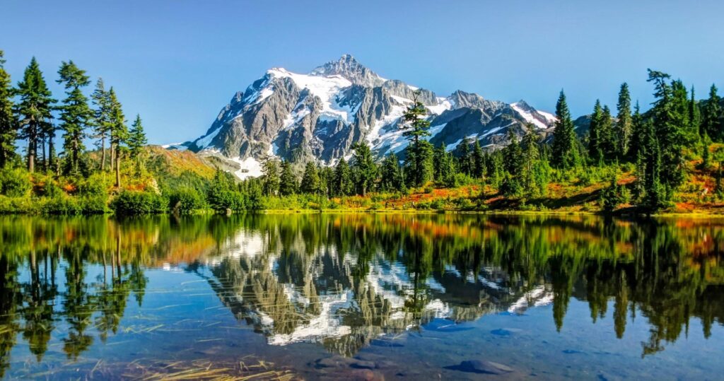
Winding along the banks of the Nooksack River, through small logging communities, past waterfalls, and alongside old-growth forest groves, this 58-mile trek ends at the base of the 10,781-foot volcano Mount Baker and one of the most photographed scenes in the country at Picture Lake with its mirror reflection of Mount Shuksan.
The end of the road at Artist Point is only open for 3-4 months in late summer and early fall so you may want to plan around that to get some of the best hikes and photo ops of Mount Baker.
Key points of interest:
- Picture Lake – Picture Lake is the centerpiece of a strikingly beautiful landscape in the Heather Meadows area. The classic alpine vista of Mt. Shuksan mirrored in Picture Lake is one of the most photographed mountain scenes in North America. A backdrop of mountains, wildflowers and colorful plant foliage make this a beautiful, universally accessible family hike.
- Artist Point – Located at the very end of Mount Baker Highway, State Route 542, Artist Point boasts 360-degree views of Mount Shuksan and Mount Baker, as well as access to a variety of trails. Due to excessive annual snowfall, this coveted destination is typically only open from late July to early October.
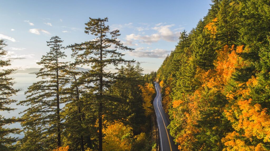
Chuckanut Drive Scenic Byway
A premier byway sometimes referred to as Washington’s Big Sur (perhaps Little Sur would be more fitting), the 24-mile curvy route hugs the sheer sandstone cliffs of the Chuckanut Mountains. The only place where the Cascade Mountains meet the sea, Chuckanut Drive overlooks Samish Bay and offers gorgeous views of the San Juan Islands and Chuckanut Bay.
Stroll through tulip fields in spring or find a cozy restaurant and feast on fresh shellfish. Search for treasures in shops or for beach glass along the water. Take a hike up past the tree line, or down along a white-sand beach. Chuckanut Drive is one of those byways that will leave you wanting to linger just a little longer.
Key points of interest:
- Historic Fairhaven – Founded in the 1890s, the Fairhaven district provides a great opportunity to stop and browse. Walk the cobblestone streets of the historic district, with restored nineteenth-century brick buildings now housing bookstores, boutiques, and restaurants, and go back to a time when Fairhaven was predicted to become a major city.
- Larrabee State Park – Set on the seaward side of Chuckanut Mountain near Bellingham, Larrabee State Park is known for its postcard views of Samish Bay and the San Juan Islands. It is also Washington’s first state park.This unique camping park on famed Chuckanut Drive offers access to great hiking, boating, fishing, shellfish harvesting and diving. A ¾-mile hike takes you to the rare sandstone cliffs and teeming tidepools of Clayton Beach. This is the perfect spot for a quiet time out, an exploratory jaunt with the kids or a romantic date.

Mountains to Sound Greenway
The Greenway connects it all: vast forests. Meadow-strewn mountain peaks. Small farms that feed city markets. Rural communities, keepers of our region’s colorful past. Vibrant cities where people want to live, and companies want to locate. Broad swaths of land for wildlife to roam. Hundreds of places for skiing and hiking, kayaking, and cycling.
Weaving together the urban and the wild, the Mountains to Sound Greenway National Heritage Area connects 1.5 million acres surrounding Interstate 90. More than 900,000 acres of land are now publicly owned, from city parks to expansive public forests. Another 100,000 acres are conserved as permanent private forests.
Key points of interest:
- Snoqualmie Falls: From time immemorial, the Snoqualmie Tribe has considered Snoqualmie Falls sacred – its birthplace of creation. Mists from the thundering 268-foot waterfall carry prayers to ancestors, and the Falls provide the gifts of food, water, life, health, and healing. Today, the Snoqualmie Tribe warmly welcomes all visitors to this sacred place to experience its power in their own way.
- Palouse to Cascades Trail – The Palouse to Cascades Trail spans Washington state from the western slopes of the Cascade Mountains to the Idaho border. Bicyclists, hikers, equestrians, skiers, and snowshoers experience Washington’s diverse and scenic landscape, traveling through evergreen forests and dark tunnels, over high trestles and spectacular rivers, and across open farmland and high desert.
- I-90 Wildlife Bridge – As you pass under this wildlife bridge, a good chance exists that elk, deer, coyotes, and/or numerous other large and small wildlife species are crossing just overhead. Watch for North America’s largest wildlife overcrossing bridge while driving along Interstate 90, between mileposts 61 and 62, about nine miles east of Snoqualmie Pass.
White Pass Scenic Byway
Diversity sums up the experience best. The nationally designated White Pass Scenic Byway boasts magnificent driving tours from the lush evergreen forests of western Washington, up and over the Cascades, and into the sage-covered rolling hills that rise up from the Tieton River drainage on the state’s east side.
Recreational possibilities—camping, fishing, hunting, hiking, skiing and boating—are easy to find here. There are charming communities to enjoy, as well as side trips revealing both the majesty of Mount Rainier and the devastation from the 1980 eruption of Mount St. Helens.
Low-elevation lakes, river valleys, foothills, subalpine ridges, forests, lush meadows and open steppes are all accessible through this gateway. Bald eagles, elk, mountain goats, black bears, marmots and salmon occupy an array of wild habitats and public lands. July and August are generally sunny and mild, with heavy snowfall November through April.
Bring along a swimsuit in the summertime; there are plenty of lakes to take a dip in. A tent will serve you well as camping is plentiful along the route.
Don’t forget your camera: the meadows, lakes and hills of this landscape host animals from elk to bighorn sheep to black bear. Eagles, ospreys and red-tailed hawks are your constant companions as you head east.
Be sure to pick up a box of peaches or cherries in Naches. There’s no souvenir like an edible one.
Key points of interest:
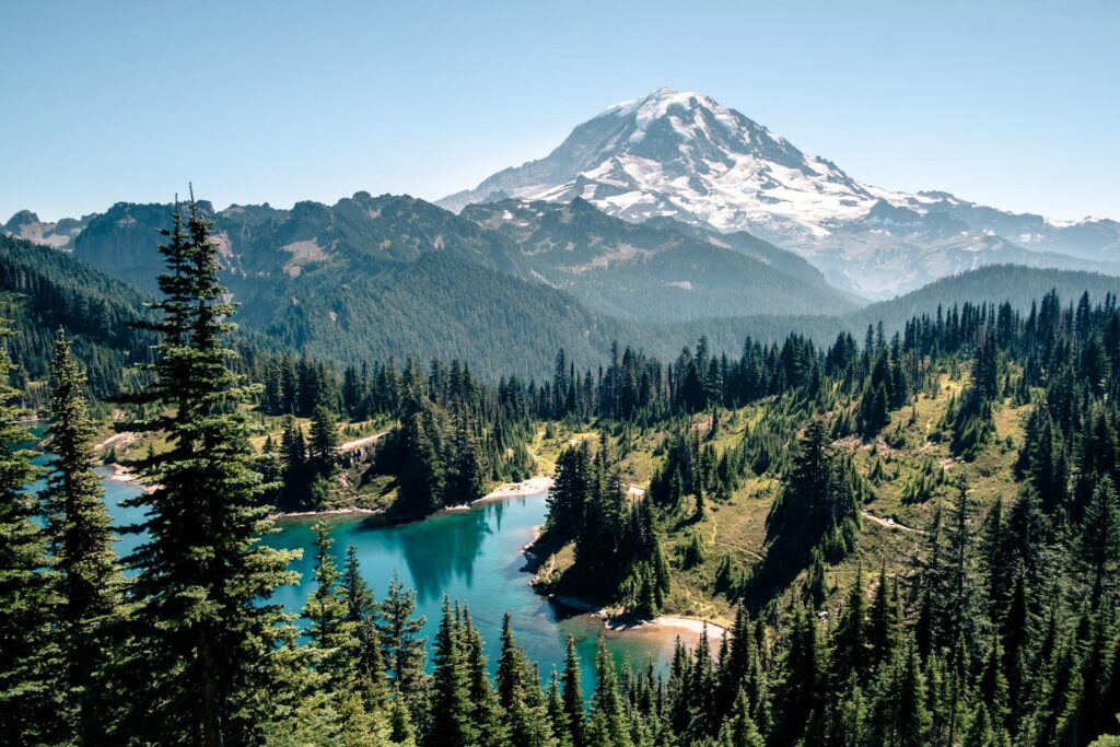
- Paradise, Mt. Rainier National Park – There are few locations within the entire National Park System as stunning as Paradise. It is nestled on the south slopes of Mt. Rainier at an elevation of 5,400-feet among wildflower meadows punctuated with glistening snowfields and groves of gnarled firs and hemlocks.
- Riffe Lake – This man-made reservoir behind Mossyrock Dam offers beautiful coves to relax and swim in, waterfalls, and several miles of hiking trails. Riffe provides good fishing for landlocked coho and Chinook salmon, plus an occasional large brown trout. Rainbow and cutthroat trout are also available.
Chinook Pass Scenic Byway
The Chinook Pass Scenic Byway runs from the rolling fields of Enumclaw west of the Cascades to the Naches Valley east of the range. Along the way, this two-lane pass wraps around the northeastern flank of iconic Mount Rainier.
Driving along this byway will give you a first-hand answer to that ubiquitous Washington State question, “Is the Mountain out?” But picture-perfect glimpses of the second tallest peak in the continental United States aren’t all this route has to offer. This is a “boots-on” byway that presents every opportunity to step out of the car into dense forests, alongside rollicking rivers and onto high desert plains. It seems there is a new microclimate every other mile, so bring along extra layers of clothes, a solid pair of shoes, and don’t forget your camera.
At the start of the byway, 14,410-foot-tall Mount Rainier steals the scene and challenges the sky. Pause in Rainier’s foothills to explore an old-growth forest or snowshoe a placid path. As you travel east, rushing water seems your constant companion, as this road follows routes carved by the White, Greenwater, American and Naches rivers long ago. Finally, the dense Douglas fir forests of the western Cascades will give way to the sparser tamaracks and ponderosa pines of eastern Washington’s foothills. At the byway’s end there are many rewards; miles of horizon, abundant wildlife, farm stands filled with local produce and, usually, warm weather and blue eastern Washington skies.
Before you jump in your car and head out, remember a portion of this route is a seasonally restricted road—plan your trip between late May and late November.
Key points of interest:
- Crystal Mountain Ski Area & Gondola – During winter, Washington’s largest ski resort, Crystal Mountain, has 2,600 acres of world-class terrain for skiers and snowboarders, along with many slope-side lodging and dining options. A new high-speed gondola allows skiers to make even more runs on those perfect powder days and is open during summer to bring visitors to the summit for breathtaking views of Mt. Rainier.
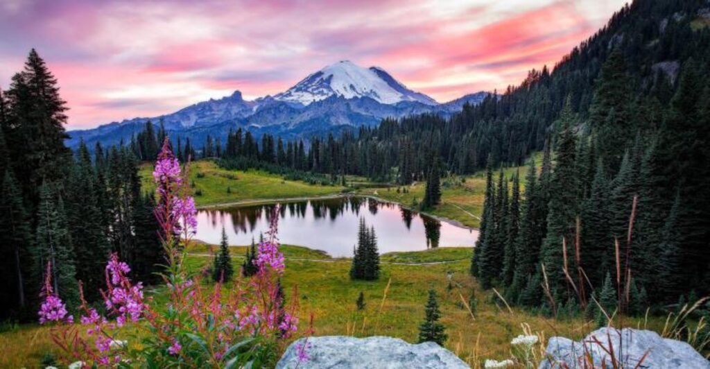
- Tipsoo Lake – About 8 miles past the entrance to Sunrise, the byway winds upward along a series of switchbacks to another popular stop and photo-op—Tipsoo Lake. Chances are you have seen this lake, with Mount Rainier reflected in its still waters, even if you’ve never visited. It’s one of the most photographed nature scenes in the United States.
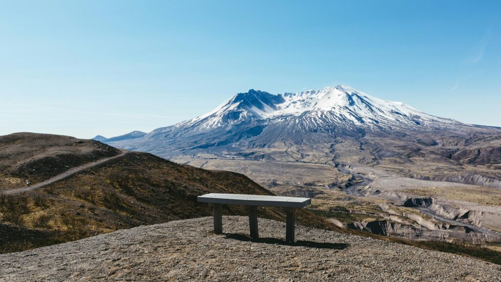
Spirit Lake Memorial Highway
This is the only scenic byway in Washington State, not to mention the United States, that enters a volcanic blast zone. Also known as the Spirit Lake Memorial Highway, SR-504 is a 52-mile journey into the scene of epic destruction that Mount St. Helens caused when it erupted on May 18, 1980.
Key points of interest:
- Forest Learning Center – Directly following the Mount St. Helens eruption, workers from the Weyerhaeuser timber company swarmed across the devastated land, hauling out enough salvaged logs to build 85,000 three-bedroom homes. The company did its part to rebuild the forest by hand-planting 18 million seedlings. Today, you can almost see a line between the trees that were farmed and the natural regeneration of plant-life at the mountain.
- Mount St. Helens Visitor’s Center – The Mount St. Helens Visitor Center opened its doors to the public a few years after the monumental eruption of Mount St. Helens. Functioning as a gateway to the mountain, over 30 miles away, the Visitor Center’s goal is to educate visitors on the historical significance of the landscape before and during the eruption. The center also focuses on the resulting impact on nearby ecosystems. The vantage point offers a view of the Western slope of the mountain, visible from both the center and walking trail.
- Coldwater Lake Boardwalk – On this short, accessible trail, interpretive displays explain how the 1980 debris avalanche from Mount St. Helens dammed Coldwater Creek creating the lake. Chewed trees, the signs of beavers at work, can often be seen around the trail.