
Palouse Scenic Byway
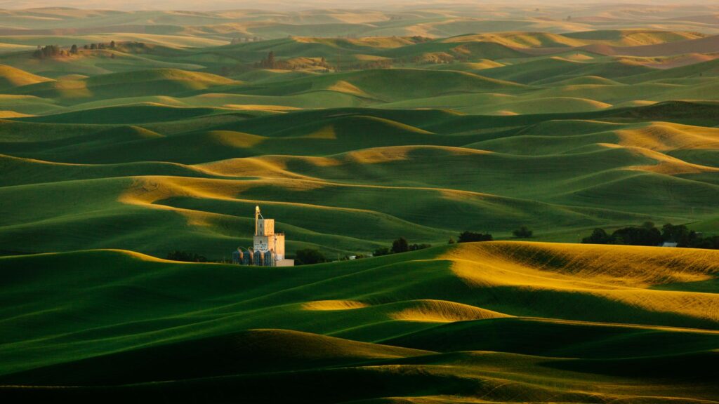
The desert land of central Washington recedes slowly and gives way to alpine forests, lakes and waterfalls. As you approach our state’s southeast corner, you’ll discover the wonderfully mesmerizing rolling wheat fields of the Palouse, some of the most productive farmland in the nation. Here you’ll find scenic beauty and people with the spirit of the resourceful pioneers who first settled these farming communities.
Thousands of acres of wheat blanket the rolling hills, and their color—from spring green to autumn gold—tells of the passing of the seasons. A viable agricultural region, the area holds the largest concentration of wheat per acre in the world. Barley, onions and 30 percent of the world’s lentils are grown here.
The Palouse is becoming famous for biking with everything from 35 miles of paved bike paths to full-on single track mountain biking, and some great hilly low traffic road riding. The land hosts waterfalls and sudden valleys. Magnificent buttes give way to panoramic views, and the horizon seems to go on forever.
Key points of interest:
- Palouse Falls State Park – A remnant of the ice-age floods and Washington State’s Official Waterfall, Palouse Falls drops from a height of 198-feet with high volumes of water flow in spring and early summer. Palouse Falls State Park is a 105-acre camping park with a unique geology and history. The park offers a dramatic view of one of the state’s most beautiful waterfalls.
- Steptoe Butte – High above the Palouse Hills on the southeastern edge of Washington, Steptoe Butte offers unparalleled views of a truly unique landscape. The warm quartzite bluff stands out against soft hills of green and mauve, an occasional barn dotting the landscape. Colors seem to shift and change in the light.

Lewis and Clark Trail
The Lewis and Clark Expedition was one of the most successful explorations in American History. President Thomas Jefferson commissioned the expedition to map the way west through the recently purchased Louisiana Territory. He instructed the Corps of Volunteers for Northwestern Discovery, as the expedition was officially named, to find a navigable passage to the Pacific Ocean.
On Oct. 10, 1805, the 33 member expedition entered what is now the state of Washington at the convergence of the Snake and Clearwater rivers in Hells Canyon. As they paddled swiftly down the Snake and Columbia rivers, the explorers began to see signs that they were close to realizing their goal. As noted in their journals, Beacon Rock marks the spot where they first detected tidal influences and knew they were approaching the Pacific Coast.
Today you can retrace this historic journey by land and even climb to the top of Beacon Rock to see the landscape much as it would have looked 200+ years ago although the “pre-dam” river would have been much shallower and swifter.
Key points of interest:
- Hells Canyon – Located at the confluence of the Snake and Clearwater rivers approximately 465 river miles from the Pacific Ocean, Lewiston is the most inland seaport on the West Coast. This was where the 1804-06 expedition of Captains Meriwether Lewiston and William Clark first entered what is now Washington State. Half day tours of the canyon are available and highly recommended.
- Walla Walla – As the unofficial capital of Washington wine country, Walla Walla is a place where scenic beauty, incredible wineries, enticing restaurants, cultural inspiration, outdoor adventures, and small-town friendliness come together to create an experience you’ll want to share again and again.
- Sacagawea State Park – The Sacagawea Heritage Trail Project is a recreational and educational trail along twenty-three miles of beautiful Columbia River shoreline in Tri-Cities, Washington. The trail is dedicated to the lone woman on the Lewis and Clark expedition.